New training manual on spatial analysis
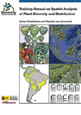
Bioversity International has released a new “Training Manual on Spatial Analysis of Plant Diversity and Distribution”.
Bioversity International has released a new “Training Manual on Spatial Analysis of Plant Diversity and Distribution”. This manual focuses on using tools based on the geographic information system (GIS), such as DIVA-GIS, a GIS software specifically designed to undertake spatial diversity analyses and Maxent, a species distribution modelling software, -to help answer common questions relating to the spatial analyses of biodiversity data. The manual provides a set of step-by-step instructions, accompanied by a series of case analyses, for using free and open-access software. Spatial analyses of inter-specific and intra-specific diversity are explained using different types of data, species presence and morphological or molecular characterization data. The case analyses focus on plants of interest for improving livelihoods (e.g. crops, trees and crop wild relatives), but they can also be applied to other organisms, such as animals and fungi.
Spatial analysis helps monitor the patterns of distribution and status of biodiversity and the results can be used to improve conservation efforts. For example, spatial studies can provide critical information on the diversity present in specific geographic areas and they can also be used for prioritizing areas for conservation, modelling potential impacts of climate change and analyzing gaps in genetic conservation efforts.
The training manual is intended for scientists and students who work with biodiversity data and are interested in improving their skills to carry out spatial analyses. The manual can be downloaded from <link http: www.bioversityinternational.org _blank external-link-new-window external link in new>Bioversity International’s website.
For more information, please contact <link mail>Maarten van Zonneveld
Related Links
- Training manual on spatial analysis of plant diversity and distribution Publications
- DIVA-GIS
- Maxent


